AlpineSense: the 3D mountain revolutionizing alpine skiing at the Milan Cortina 2026 Games
Combining high-precision three-dimensional surveys, athletes' biomechanical data, and environmental information in a single digital platform to verify race courses, improve athletes' performance, and make descents safer. This is the challenge at the heart of AlpineSense – Master Every Slope, the project developed by Politecnico di Torino together with Università degli Studi di Roma “Foro Italico” and Università IUAV di Venezia, as part of the research and experimental activities related to the Milan–Cortina 2026 Winter Olympics.
A project that develops new methods for analyzing sports performance, enhancing athlete safety, and understanding the complexities of alpine environments through a multidisciplinary approach integrating engineering, geomatics, and motor and sports sciences.
“The world of sport represents a complex arena in which to develop research and apply technological innovations. The Milan-Cortina Winter Olympic Games are an extraordinary testing ground where we are trialing AlpineSense. Politecnico di Torino pioneered the project, thanks to the collaboration with colleagues from Università degli Studi di Roma “Foro Italico” and Università IUAV di Venezia. This unique analysis examines both the morphological and physical characteristics of the mountains and race tracks, along with data collected directly from the athletes,” explains Rector Stefano Corgnati.
The project adopts a cutting-edge approach that combines high-precision three-dimensional modeling of racecourses with the collection and analysis of biomechanical and environmental data that define the skier's path. It also includes interactive visualization of information within a cohesive digital environment. The goal is to represent, analyze, and understand the complex alpine environments where high-level competitions occur, providing athletes and technical staff with innovative tools for optimizing performance and strategic planning.
Developing slopes’ digital twins
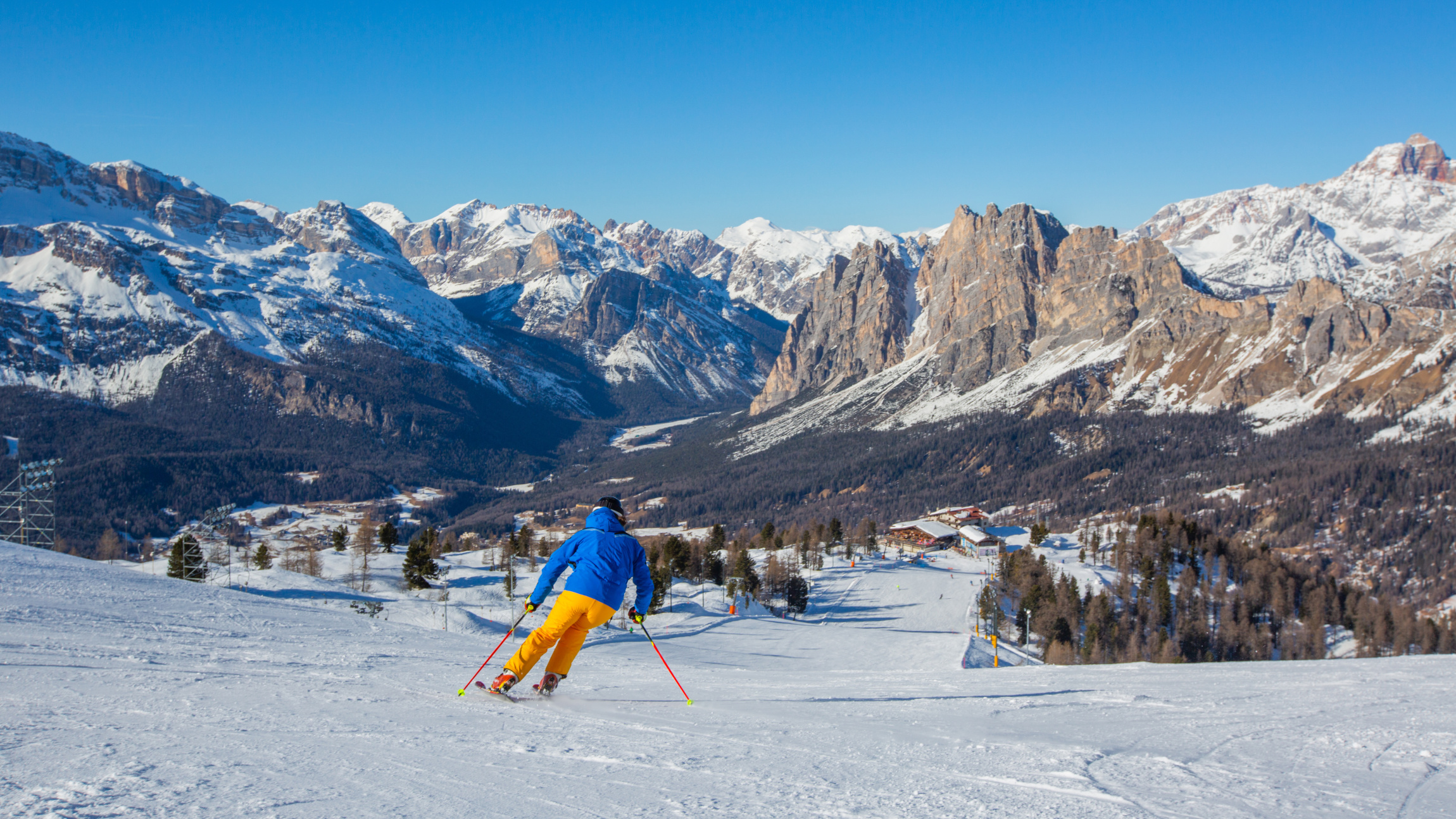
The focus of this research is to create an accurate digital twin of the slopes for the Milan Cortina 2026 Olympics, including Pomedes, Schuss, Olympia delle Tofane, and Vertigine. The objective is to bridge the gap between traditional territorial surveys and detailed analyses by providing a continuous, accurate, and scientifically robust three-dimensional model of the mountain slopes. The reconstruction process relies on aerial surveys conducted in both snowy and snow-free conditions using two complementary methods. Drones equipped with LiDAR technology allow for the direct acquisition of the three-dimensional geometry of the terrain and surfaces, even in areas with complex morphology and vegetation. Meanwhile, photogrammetry is utilized to generate high-quality radiometric models, which are essential for a more comprehensive understanding of the landscape.
At this point, the aerial surveys were georeferenced using multi-constellation systems in RTK (Real-Time Kinematic) mode to ensure centimeter-level accuracy and full spatial consistency between the different datasets.
The operations included a dynamic survey of the track using SLAM (Simultaneous Localization and Mapping) technology. This approach enables us to accurately describe the track in its true spatial context, resulting in a highly detailed three-dimensional representation of the terrain as it is traversed by athletes.
The outcome is a continuous, precise, and high-resolution 3D model that captures the mountain's complexity, from significant morphological features to subtle variations in the terrain that can influence performance.
Data on athletes' behavior
Biomechanical data, collected directly on the slopes, were added to the geometry of the slopes. Advanced inertial sensors (IMUs) were integrated into the technical clothing of skiers on the slopes being analyzed, capable of detecting with great precision how the skier accelerates, changes direction, or tilts their torso during the descent. At the same time, a high-precision GPS system tracks the exact route taken on the slope step by step.
All this information—ranging from instantaneous speed to the inclines of curves and even the most intricate sections of the track—is automatically analyzed. This analysis allows us to identify key moments during the descent and the most complex parts of the course. As a result, we can reconstruct the interaction between the athlete and the track with unprecedented detail. This includes identifying more efficient descent lines, understanding tactical choices, pinpointing the most challenging sections, and evaluating areas that offer the greatest potential for improvement. This method significantly surpasses traditional video analysis and simple timing measurements.
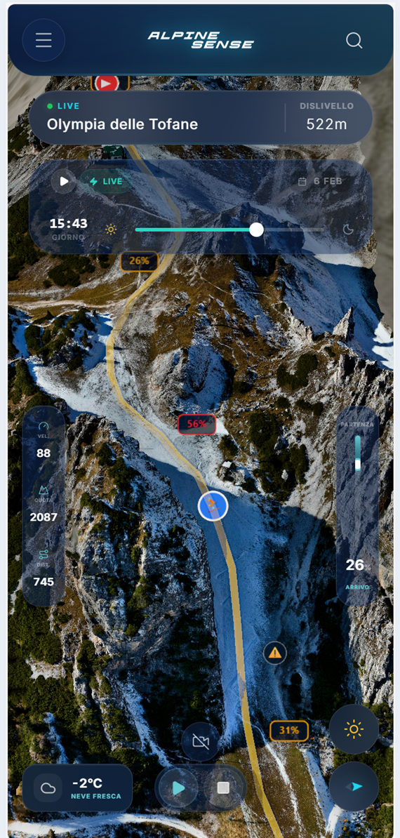
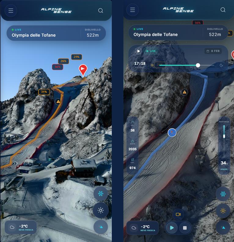
A web platform designed to make data accessible
To make this wealth of information accessible, the team is developing an interactive web platform that enables users to explore high-resolution 3D models directly from their browsers, including mobile devices. The application will allow users to compare summer and winter conditions on the slopes, view athletes' trajectories synchronized with biomechanical data, analyze how shadows affect the snow throughout the year, and access information on weather, snow conditions, slopes, and terrain.
The vast amount of data generated by AlpineSense offers a new perspective on athletic training. Coaches and technicians can objectively analyze race lines to determine where time is gained or lost. They can also correlate an athlete's technique with environmental conditions and design targeted training sessions for specific sections of the course. This system introduces a shared language and methodology based on verifiable data and intuitive visualizations, which can significantly innovate the traditional approach to high-level alpine skiing.
This tool is primarily designed for athletes and technical staff, but it is also intended to benefit sports event organizing committees. They can use it for logistics planning, assessing track safety conditions, and communication. Additionally, sports federations and Olympic committees may find the system's objective tools valuable for comparative performance evaluation and scientific documentation of competitions.
The integration of comprehensive datasets creates new research opportunities for those studying sports science and biomechanics, particularly in performance modeling and athlete-environment interaction.
Local authorities and mountain safety organizations can use the data for monitoring purposes, sports infrastructure maintenance, and safety assessments. Finally, enthusiasts and amateur skiers can also benefit from terrain visualization and simulations to make more informed choices about where and when to practice their sport, improving safety and the quality of the experience.
A rich dataset going beyond skiing
“Politecnico is increasingly establishing itself as a university for sport – emphasizes Vice Rector for Society, Community, and Program Implementation Stefano Sacchi – The applications of this initiative will be highly beneficial for alpine skiing competitions and training, enhancing both performance and safety. In the future, we plan to broaden the scope of our activities to include all mountain sports, such as cross-country skiing and mountain biking, catering to both professionals and amateurs. This is the essence of our university: to find technological solutions to challenges that are relevant to society. In keeping with the mission of a polytechnic institution, the skills we develop will be shared with the entire community, fostering a spirit of giving back that generates benefits beyond just the Olympic and sporting arenas”.
The impact of AlpineSense is not limited to ski slopes. Firstly, the methodology developed can be extended to other Olympic winter sports: from snowboarding to cross-country skiing, biathlon, skeleton, and bobsleigh. The potential applications also extend to summer sports in mountain environments, such as mountain biking and trail running, and to the creation of immersive experiences in virtual or augmented reality, which are useful in the fields of education, tourism, and training.
It also lays the foundations for numerous future developments, including other application contexts. The 3D models and environmental data collected provide valuable tools for studying snow transformations, analyzing climate change in mountainous areas, and assessing avalanche risk. They also make it possible to identify ground instability phenomena and plan measures to prevent hydrogeological risk.
“In AlpineSense, data becomes a compass: high-precision measurements and observations are transformed into reliable indicators for better understanding athletic performance and the mountain environment, guiding informed and conscious decisions,” concludes Tania Cerquitelli, professor in the Department of Automation and Computer Science (DAUIN), who coordinated the project.
“Sport serves as an extraordinary laboratory for engineering – continues Professor Cerquitelli – In this complex and dynamic environment, we can apply cutting-edge instrumentation, integrate various types of data—including movement, terrain, weather and snow conditions, images, digital models—and combine expertise from both engineering and sports. This allows us to apply advanced analytical methods. The impact of this work extends beyond the sports field. The technologies and models developed can also be used to enhance performance and safety, assess the effects of climate change on mountainous regions, and support risk assessments related to natural phenomena, such as avalanches and hydrogeological instability. This is how innovation, beginning with sports, translates into measurable benefits for society as a whole”.